
Mercer Bay Loop.
The most cinematic short walk in the area. An hour around the clifftops, with views out to the Tasman and back to Piha.
About
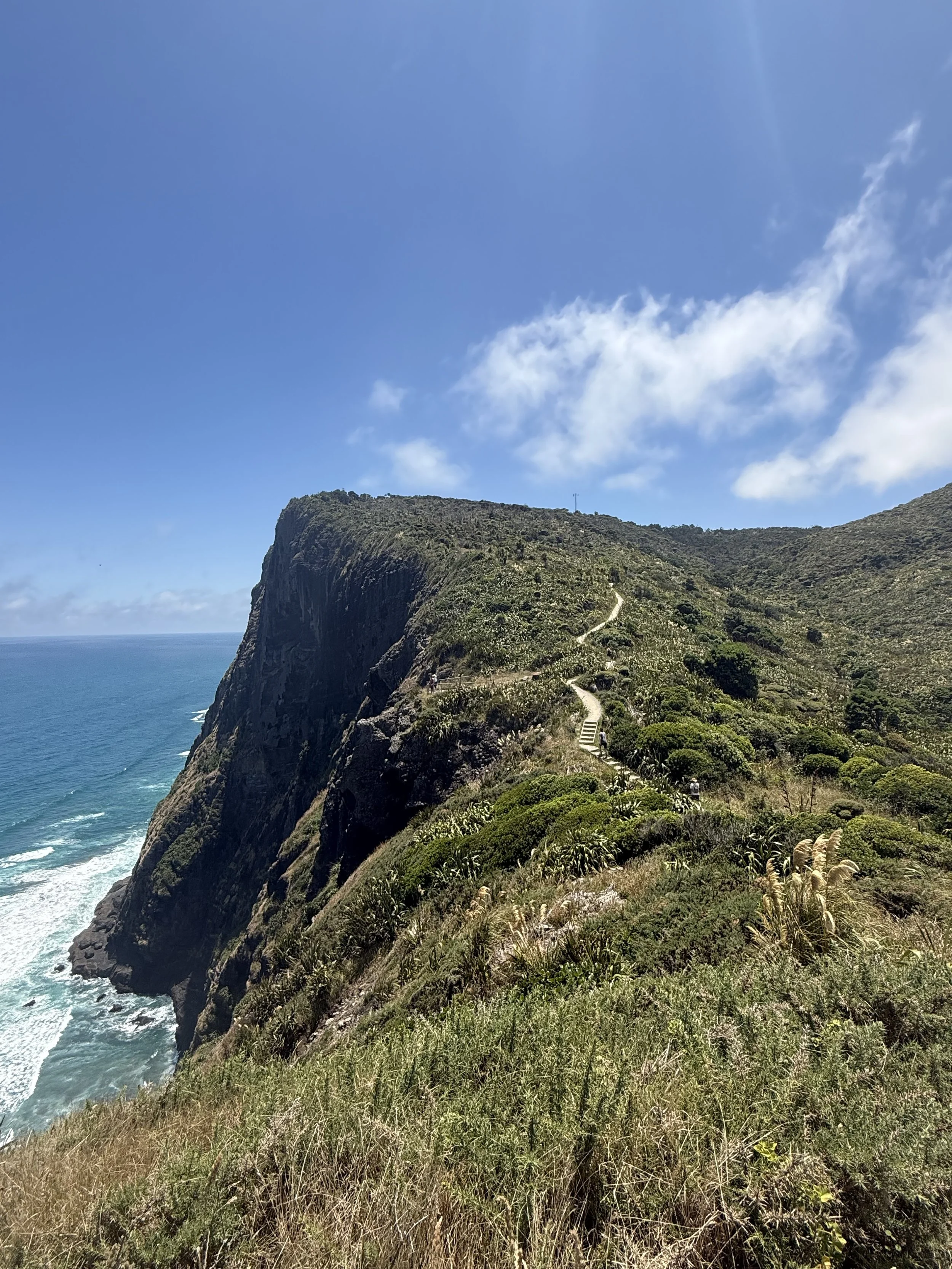
Mercer Bay Loop is the walk to do on a clear day when you want to understand the scale of the Auckland west coast. The track starts from the Log Race Road carpark above South Piha and loops around the cliffs above Mercer Bay — a small, inaccessible cove where the cliffs drop straight into the Tasman. You're walking along the edge of the country, more or less, with views back to Piha and Lion Rock in one direction and out to the open ocean in the other.
The cliff-edge sections are properly dramatic. Some are fenced, some aren't, and the drops are real. Keep children close and yourself back from the edge — the wind comes off the Tasman with no warning and the ground near the edge isn't always as stable as it looks. This isn't a walk to do casually or in poor weather; it's a walk to do well, on the right day.
The loop takes about an hour and a half at a normal pace, longer if you stop for the views (you should). The track is mostly formed and not steep, but it has exposed sections that aren't pleasant in rain or strong wind. Bring layers; the weather on the cliffs can be ten degrees colder than the village below, and the wind picks up in the afternoon.
Worth timing for late afternoon. The hour before sunset, the light over the cliffs and the water turns gold and the bush behind you lights up — it's one of the most photographed sections of coastline in Auckland for good reason. If you only do one walk in the wider Waitākere Ranges, this is the one most likely to stay with you.
The track also passes the historic Te Ahua Pā site, a Te Kawerau ā Maki pā site of significant cultural importance. Information panels along the route describe the site's history; the site itself should be respected as the wāhi tapu (sacred place) it is. Stay on the track, don't disturb anything, and treat the passage through with appropriate care.
Trailhead:
Mercer Bay Loop, Log Race Road, Piha. Drive up Log Race Road from the south end of Piha; the carpark is at the top.
Difficulty:
Moderate. Mostly formed track but with exposed cliff-edge sections and weather considerations.
Distance:
Around 3.5 km loop.
Duration:
1.5 hours at normal pace.
Surface:
Formed track with some boardwalk and stairs. Exposed in places.
Highlights:
Cliff-top views, Mercer Bay (visible from above but not accessible), Te Ahua Pā site, ocean panoramas.
Toilets:
One toilet at the beginning of the trail.
Dogs:
On lead.
Cultural significance:
Track passes Te Ahua Pā — a Te Kawerau ā Maki wāhi tapu (sacred place). Stay on track and treat the area with respect.
Best for:
Clear-day visitors, photographers, anyone wanting one walk that captures the scale of the coastline, late-afternoon timing for the light.
Not for:
Poor weather, strong wind, anyone uncomfortable with cliff exposure.
Safety note:
The cliff-edge sections are exposed and the drops are real. Stay on the track. Keep children close. Don't attempt this walk in strong wind, heavy rain, or poor visibility — the conditions on the cliffs can be much worse than in the village below, and the exposure becomes genuinely dangerous.
Check current track status with Auckland Council before setting out. The Waitākere Ranges have ongoing track closures for kauri protection and slip recovery.
